
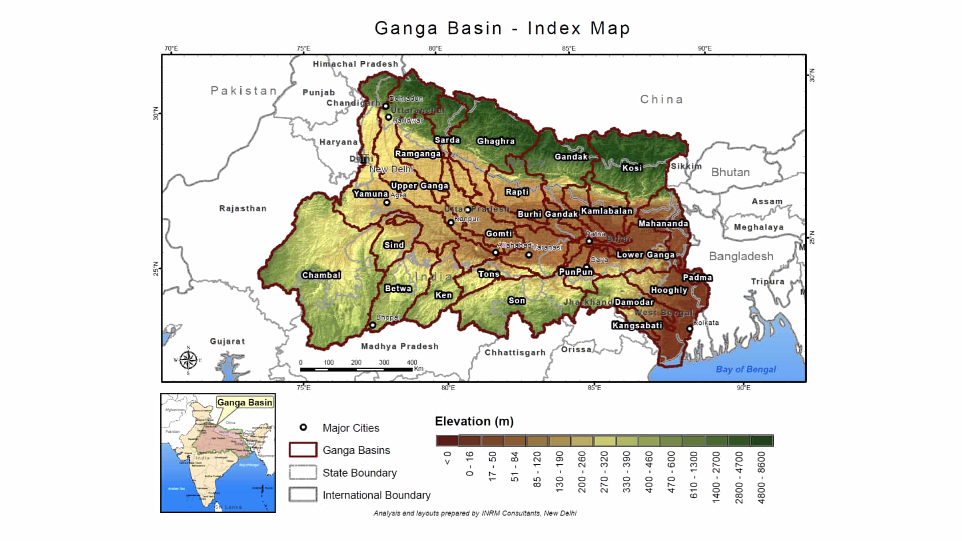
 Figure: Ganga Basin Index Map
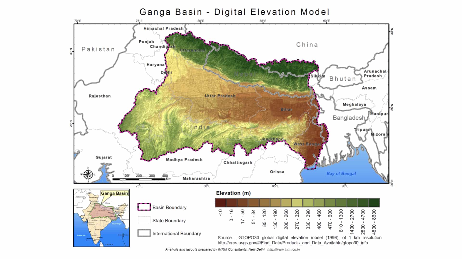 Figure: Ganga Basin Digital Elevation Model
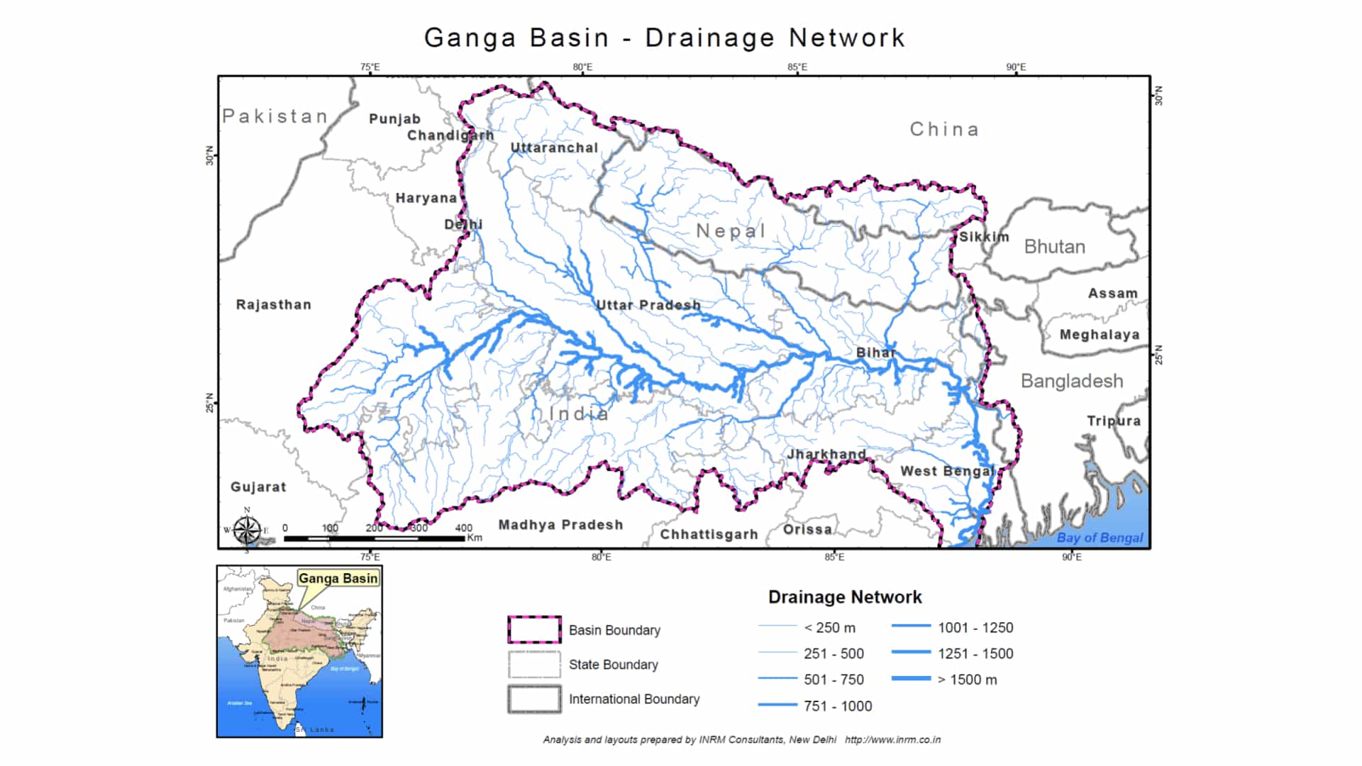 Figure: Ganga Basin Drainage Network
Project Summary
The study was aimed at supporting the strategic assessment of the Ganga River Basin through the hydrological simulation model of Ganga Basin. A model of the Ganga Basin was created by using SWAT hydrological model and calibrated and validated after incorporating all the manmade changes to reflect the present hydrological regime. The validated model was used to generate various scenarios for implications on account of future developments on quantity and quality of water.
The study also produced a knowledge base that can be used for independent dissemination to a much diversified set of stakeholders and can work very effectively towards generating consensus on future pathways for sustainable development.
Study Objective
Following are the specific objectives achieved during the course of the study:
- A water balance model of the Ganga Basin and its use to better understand hydrologic implications of various current and future scenarios,
- Construction of a shared knowledge base using the readily available and generated information, and
- Preliminary assessment of spatio-temporal water pollution in the Ganga basin on account of present and future development.
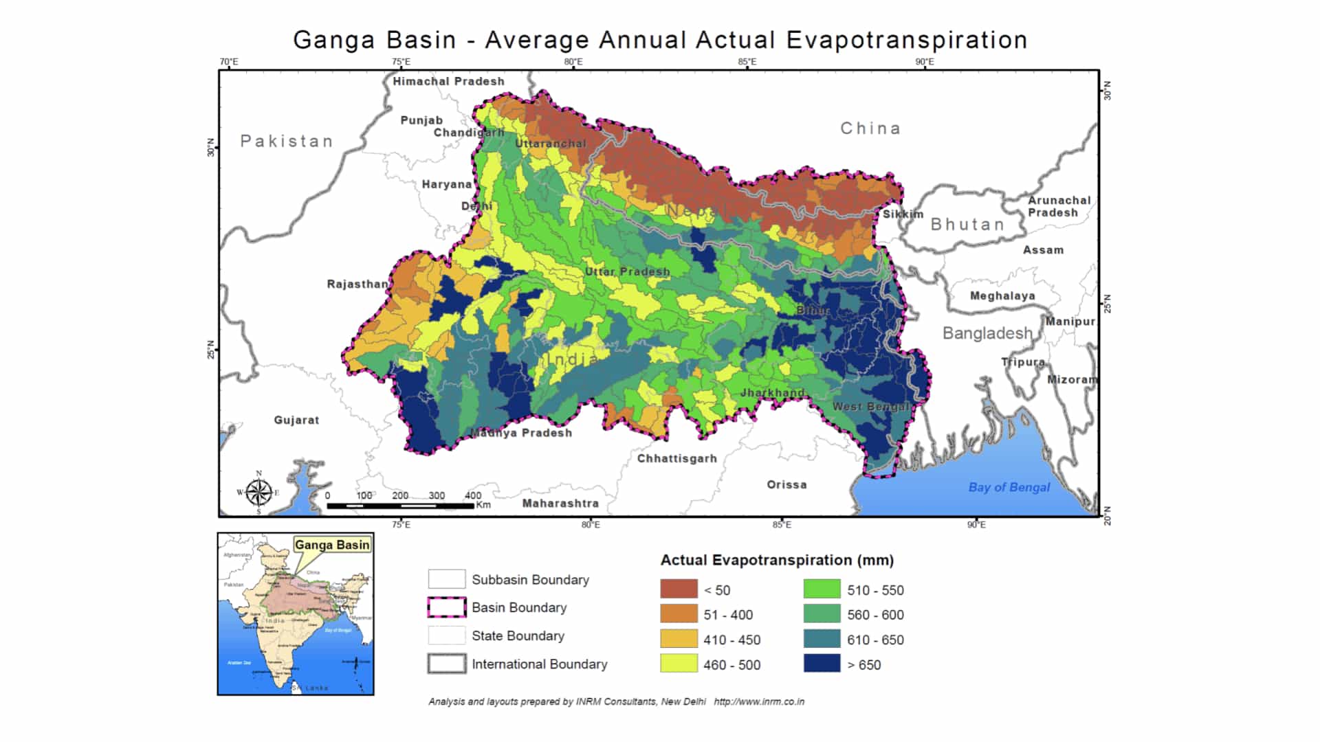
Figure: Spatial distribution of Average Annual Actual Evapotranspiration (Ganga)
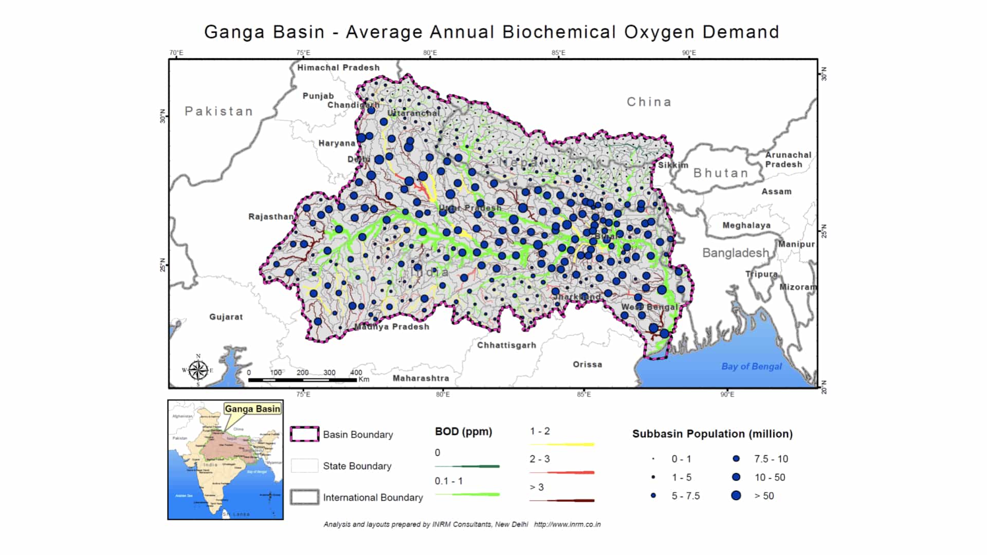
Figure: Spatial distribution of Average Annual BOD Load (Ganga)
Findings
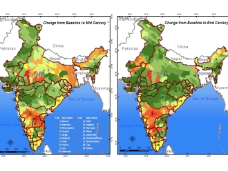
Various scenarios were contemplated to evaluate the implications of the future population growth and development. Additional scenarios have also been formulated to quantify the implications of the projected climate change on quantity and quality of Ganga river. In all five main scenarios have been contemplated (Scenario A to E). The first scenario (Scenario A) is geared to capture the present baseline. This scenario is essential to understand the present status of the Ganga system. The scenario B is meant to simulate the implication of ensuring minimum stream flow at all times. This has been ensured by reducing the diversions, if required. The Scenario C is meant for capturing the implication of development during the period 2020-30. This scenario is created by adding the increased demand for domestic, industry and irrigation on top of the present demand. The Scenario D has been formulated to evaluate the implication of development of the projects in Nepal. The level of development has been taken as equivalent of 5, 10 and 50 BCM/year of diversion respectively through three sub-scenarios namely D5, D10 and D50. Lastly, Scenario E has been devised to evaluate the implication of climate change on the water resources of Ganga for periods 2020-30 and 2045-55.
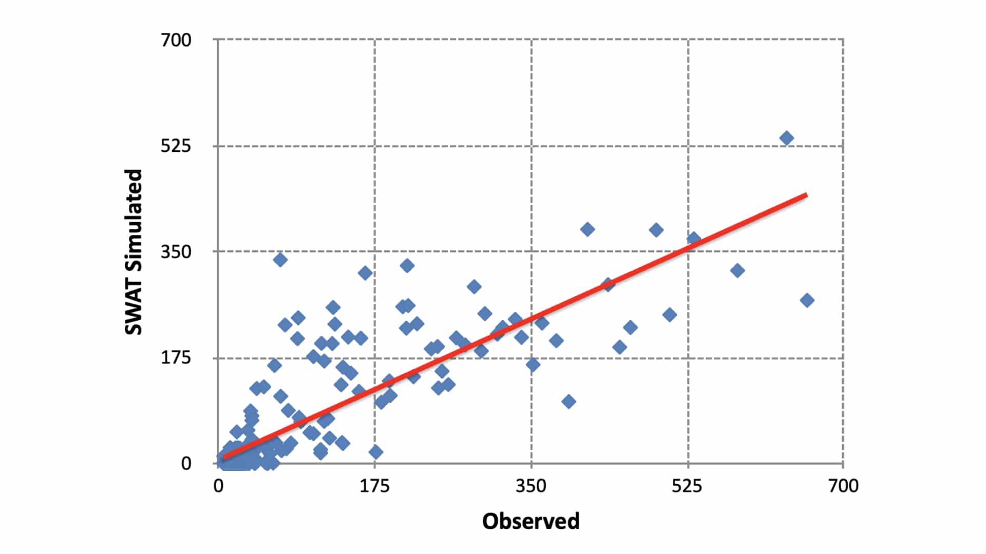
Figure: SWAT output comparison Locations and model efficiency parameters
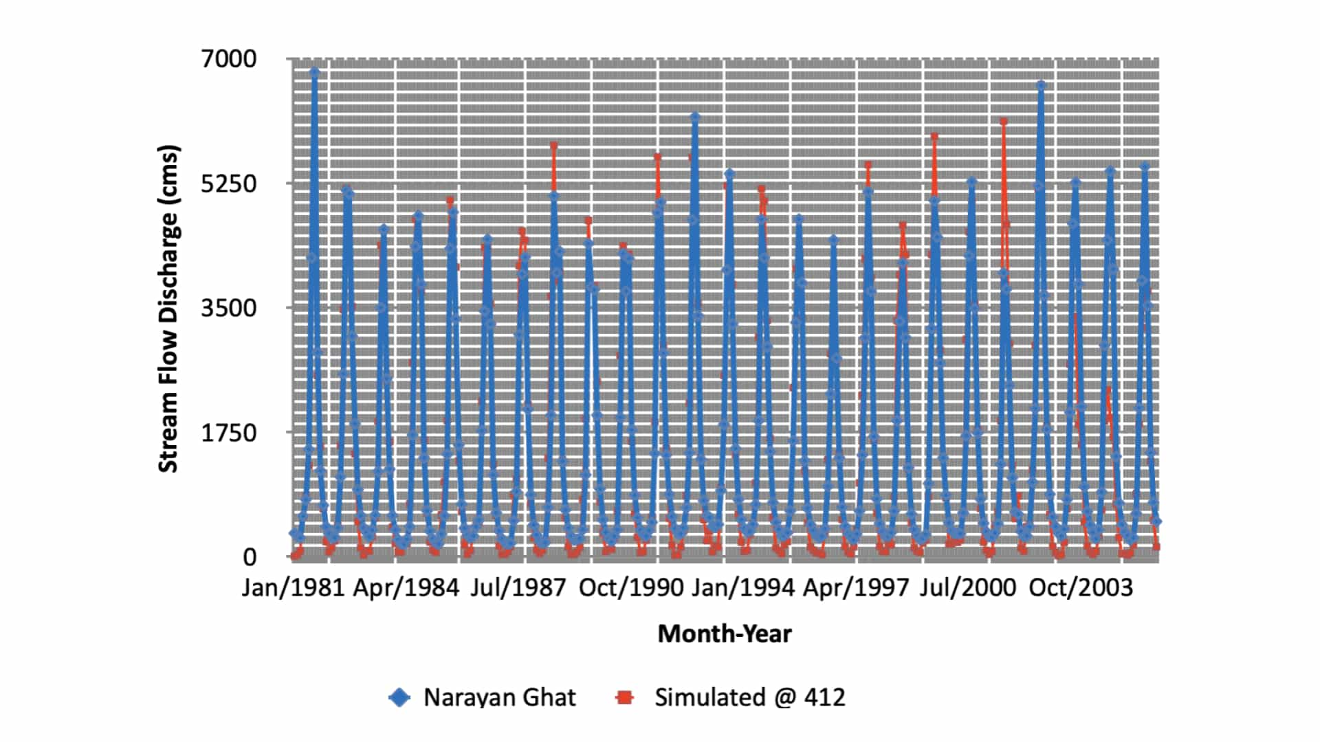
Figure: Narayan Ghat on Narayani river Catchment area 31,100 sq km. Comparison period: 1969 - 2001
These scenarios have been created and analysed. On comparing the BOD concentration for Scenario C with those of Scenario A it was found that, for high rainfall year the relative changes were not that significant and as expected due to high rainfall year the flow were high and thus even the increased population did not present major problem along the main Ganga river. However even in high rainfall year some of the major tributaries like Ramganga, Upperganga, Kandak, Kosi, Gaghra, Tons, and Sone all experienced high BOD concentration of as much as 50% or more than the Scenario A. On making comparison for the average and low rainfall years the situation is worse with increase of as much as 100% change from the baseline scenario making even good river bodies in baseline scenario A would be under water quality violation due to change in irrigation demand and increased population in the year 2025.
The study has generated very large outputs that are not only covering a range of spatial units but also a range of temporal scales. It is not possible to present all these outputs and findings in a single report. Therefore a standalone GIS based framework has been formulated to help users to interactively explore the system in terms of various features of the Ganga system along with the SWAT outputs at various levels of details of their choice. This system shall have huge advantage as a dissemination tool for creating consensus by presenting the various options of development to the stakeholders and policy makers in an understandable manner.
Linkage to the SDGs
Goal 3: Good health and well-being
Ensure healthy lives and promote well-being for all at all ages.
The Ganga River Basin is home to almost one third of the population of India. Strategic assessment with respect to the quality and quantity of the basin shall lead to sustainable development under present and future scenarios for overall well-being of the communities of the basin.
Goal 6: Clean water and sanitation
Ensure availability and sustainable management of water and sanitation for all.
The study has provided a very comprehensive knowledgebase on the spatio-temporal information on quantity and quality of water in the basin not only for present but also under climate change situation. The knowledge shall help in formulating policies that shall lead to sustainable management of water and sanitation in the Ganga Basin.
Goal 11: Sustainable cities and communities
Make cities and human settlements inclusive, safe, resilient and sustainable.
The strategic assessment has also dealt with the water demands as well as the pollution loads of the urban cities of the Ganga Basin both under present and future scenarios of climate change.
Goal 13: Climate action
Take urgent action to combat climate change and its impacts.
The assessment has provided a very detailed information on potential impacts of climate change water quantity and quality, magnitude and frequency of floods and droughts, sediment erosion, as well as impacts on agriculture.
Goal 15: Life on land
Protect, restore and promote sustainable use of terrestrial ecosystems, sustainably manage forests, combat desertification, and halt and reverse land degradation and halt biodiversity loss.
The most difficult part in the terrestrial ecosystems is to evaluate the sustainability. The framework developed has this potential by simulating the biophysical processes using the hydrological model. Implications of the changing land use have been quantified and it is possible to evaluate the potential impacts of implementing various programmes such as afforestation, change in cropping patterns, watershed management, etc., through simulation in an integrated manner which can help in selection and the success of such programmes.
We create integrated solutions for all issues Water
Let's connect
Integrated solutions. Domain expertise. Issue analysis.
Reach out to discuss a potential collaboration, something that piqued your interest in our work, just one planet enthusiast to another - we look forward to hearing from you!
Get in touch with us
+91 9717893921
5-B-2, B Block, 5th Floor, R&I Park, IIT Delhi, New Delhi - 110016, India